Planning a trip to New York City can feel overwhelming. The city is massive, spread across five boroughs, and packed with hundreds of neighborhoods. Without a proper NYC atlas guide, it is easy to get lost both literally and in planning.

That is exactly why this guide exists. Think of it as your personal New York City travel map, broken down into simple sections. Whether you are visiting for the first time or returning for another adventure, this guide will help you understand the city, navigate it confidently, and make the most of every hour you spend there.
By the end of this article, you will know which boroughs to explore, what key areas to focus on, and which landmarks deserve a spot on your itinerary. Let us get started.
What Is a New York City Atlas?
A New York City atlas is more than just a map. It is a complete visual and informational guide to the city’s geography, neighborhoods, transit routes, and major landmarks.
In traditional terms, an atlas is a bound collection of maps. For NYC, that means detailed layouts of all five boroughs, subway lines, major streets, parks, and points of interest. In a modern travel context, the term also covers digital travel guides and apps that help you navigate the city.
For tourists, a good NYC atlas guide serves two purposes. First, it shows you where things are. Second, it helps you plan logical routes so you are not zigzagging across the city wasting time and energy.
When I first visited New York, I made the mistake of not planning routes properly. I ended up walking forty minutes in the wrong direction because I did not understand how the numbered streets and avenues worked. A proper travel atlas would have saved me that headache.
Overview of NYC Boroughs
New York City is made up of five boroughs. Each one has its own personality, culture, and set of attractions. Knowing the difference between them is the first step in building your NYC itinerary.
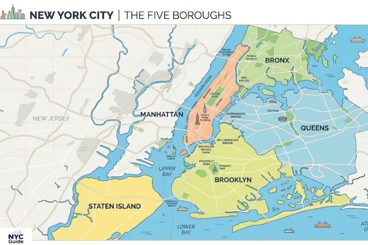
Manhattan
Manhattan is the borough most visitors picture when they think of New York City. It is a long, narrow island surrounded by the Hudson River to the west and the East River to the east.
This is where you will find Times Square, Central Park, the Empire State Building, Wall Street, and most of the city’s famous museums. Manhattan is divided into neighborhoods that run roughly from south to north Lower Manhattan, Midtown, and Upper Manhattan.

Getting around Manhattan is relatively straightforward. Streets run east to west, avenues run north to south, and most of the grid is numbered. Once you understand the layout, navigating feels natural.
Best for: First-time visitors, sightseeing, dining, shopping, Broadway shows.
How to reach: All major transit lines connect to Manhattan. JFK, LaGuardia, and Newark airports all have direct transit options into the borough.
Brooklyn
Brooklyn sits just across the East River from Lower Manhattan. It is the most populous borough and one of the most culturally rich.
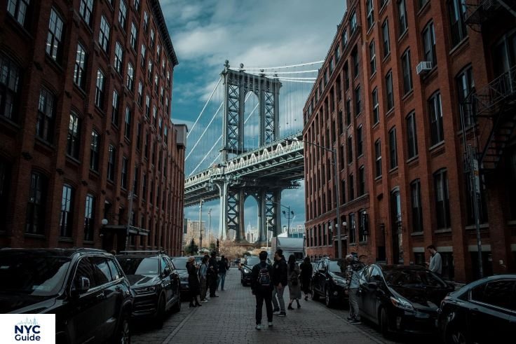
Neighborhoods like Williamsburg, DUMBO, Park Slope, and Bushwick each have distinct vibes. DUMBO offers stunning views of the Manhattan skyline and the Brooklyn Bridge. Williamsburg is known for its food scene and independent shops. Park Slope is family-friendly and leafy.
Brooklyn has transformed significantly over the past two decades. It is no longer just a place people pass through it is a destination in itself. My friends spent three full days in Brooklyn without ever needing to cross back into Manhattan, and they said it was one of their favorite trips.
Best for: Food lovers, art enthusiasts, photography, local culture.
How to reach: Multiple subway lines including A, C, F, G, N, R, and 2/3 connect Brooklyn to Manhattan.
Queens
Queens is the largest borough by land area and the most ethnically diverse county in the entire United States. This diversity shows up most clearly in its food. You can find authentic cuisine from virtually every country in the world here.
Key areas include Flushing (famous for its Chinatown and Korean food), Jackson Heights (South Asian and Latin American food), Astoria (Greek and Middle Eastern food), and Long Island City (contemporary art and Manhattan skyline views).

Queens is also home to JFK Airport and LaGuardia Airport, so many visitors technically enter New York through this borough without ever exploring it. That is a missed opportunity.
Best for: Food tourism, cultural exploration, budget travel.
How to reach: The 7 train is often called the International Express because it passes through so many ethnic neighborhoods. The N, W, A, E, and F trains also serve Queens.
The Bronx
The Bronx is the only borough of New York City connected to the mainland United States. It sits north of Manhattan and has a character entirely its own.
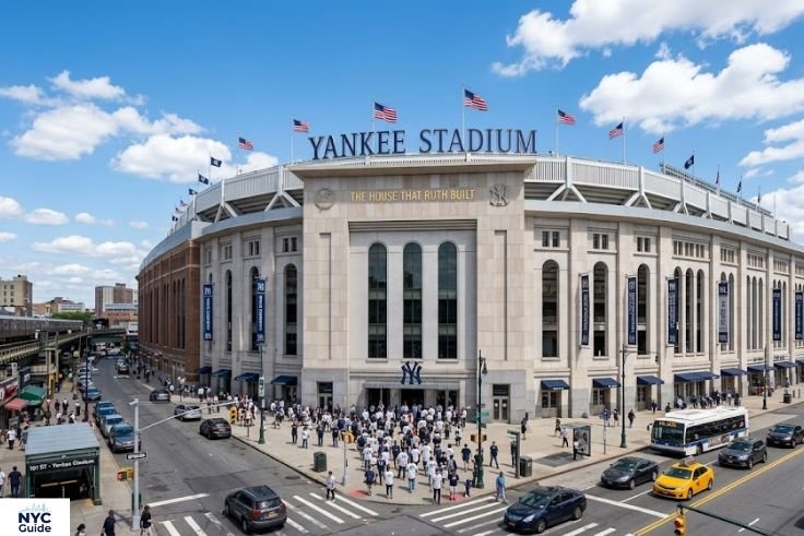
It is the birthplace of hip-hop and home to the New York Yankees, the Bronx Zoo, and the New York Botanical Garden. The Bronx often gets overlooked by tourists, but that is starting to change. Areas like Arthur Avenue sometimes called the real Little Italy offer incredible Italian food without the tourist markups of Manhattan.
If you are traveling on a budget or want to experience a more authentic side of the city, the Bronx deserves a day or at least a half-day visit.
Best for: Sports fans, nature lovers, food explorers, budget travelers.
How to reach: The 2, 4, 5, 6, and D trains run into the Bronx from Manhattan.
Staten Island
Staten Island is the most suburban of the five boroughs. It sits southwest of Manhattan and is the only borough not directly connected to the NYC subway system. Instead, you reach it by the Staten Island Ferry, which is free and offers beautiful views of the Statue of Liberty and the Manhattan skyline.
Many tourists only take the ferry as a sightseeing experience and never step foot on the island itself. But Staten Island has a quiet charm worth exploring particularly Snug Harbor Cultural Center, the Staten Island Greenbelt, and the Staten Island Museum.
Best for: Day trips, scenic ferry rides, nature walks.
How to reach: Take the free Staten Island Ferry from Whitehall Terminal in Lower Manhattan. The ride takes about 25 minutes each way.
Key Areas on the NYC Map
Within the boroughs particularly Manhattan certain areas function almost like cities within a city. Understanding these zones helps you plan efficient days.
Midtown
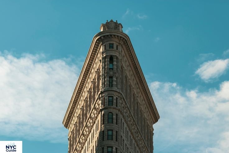
Midtown Manhattan is the heart of New York City for most visitors. It runs roughly from 34th Street to 59th Street and contains some of the most recognizable landmarks in the world.
Times Square, the Empire State Building, Rockefeller Center, the Chrysler Building, Grand Central Terminal, Bryant Park, and the Museum of Modern Art (MoMA) are all in Midtown. Fifth Avenue runs through it and is lined with flagship stores, hotels, and cultural institutions.

Midtown is busiest during weekday morning and evening rush hours. If you want to visit Times Square without the shoulder-to-shoulder crowds, go early in the morning before 8 AM or late at night. We made the mistake of visiting at 6 PM on a Friday and could barely move.
Best time to visit: Early morning for landmarks, evenings for the light shows and atmosphere.
Budget tip: Most Midtown attractions have free street-level experiences. You only pay when entering buildings or observation decks.
Downtown
Downtown Manhattan covers everything south of 34th Street. This area includes several distinct neighborhoods, each worth exploring.
The Financial District (FiDi) is home to Wall Street, the New York Stock Exchange, and the 9/11 Memorial and Museum. Just north of it is Tribeca and SoHo known for upscale dining, art galleries, and boutique shopping. The Lower East Side has a rich immigrant history and now hosts a buzzing bar and restaurant scene. Chinatown and Little Italy sit side by side and offer vibrant street culture and cheap, excellent food.
Downtown is also where you catch the ferry to the Statue of Liberty and Ellis Island one of the most important stops on any NYC travel plan.
Best for: History, culture, architecture, food, and iconic landmark access.
Uptown
Uptown generally refers to the area north of 59th Street in Manhattan. It includes the Upper East Side, the Upper West Side, Harlem, and Washington Heights.
The Upper East Side is home to Museum Mile a stretch of Fifth Avenue that contains the Metropolitan Museum of Art, the Guggenheim, the Whitney (actually now in the Meatpacking District but worth mentioning), and several other world-class institutions. The Upper West Side borders Central Park and has a more relaxed, residential feel.
Harlem is one of the most culturally significant neighborhoods in American history. It was the center of the Harlem Renaissance in the 1920s and remains a hub of African American art, music, and culture. The food scene in Harlem is outstanding particularly the soul food restaurants on 125th Street.
Best for: Museums, culture, local food, Central Park access.
Must-See Locations on the NYC Atlas
No NYC travel map is complete without these iconic landmarks. Here is what you need to know before you visit each one.
Central Park
Central Park is the green heart of Manhattan. It covers 843 acres and sits between the Upper East Side and the Upper West Side, running from 59th Street to 110th Street.
The park is free to enter and open every day of the year. Inside, you will find Bethesda Fountain, the Bow Bridge, Strawberry Fields (a tribute to John Lennon), the Central Park Zoo, Belvedere Castle, and the Reservoir.

The best way to explore Central Park is on foot or by renting a bike. I spent an entire morning just wandering with no specific route and still discovered new corners I had never seen before. The park looks completely different in every season spring blossoms, summer greenery, autumn foliage, and winter snow each create a different atmosphere.
Opening hours: 6 AM to 1 AM daily.
Admission: Free. Some attractions inside the park (like the zoo) charge entry fees.
Best time to visit: Early morning on weekdays to avoid crowds. Weekends get very busy, especially around Bethesda Fountain and Bow Bridge.
Photo tip: Bow Bridge at sunrise gives you one of the most beautiful and least crowded shots in all of NYC.
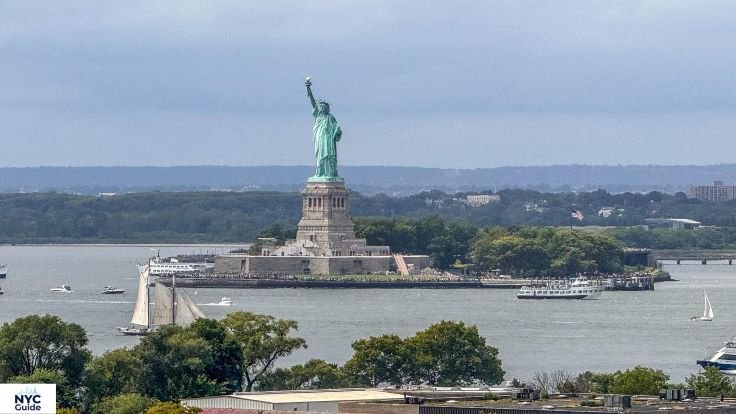
Statue of Liberty
The Statue of Liberty stands on Liberty Island in New York Harbor. It is one of the most recognized symbols in the world and a must-visit on any complete NYC travel plan.
To visit the statue, you need to take a ferry from Battery Park in Lower Manhattan or Liberty State Park in New Jersey. The ferry itself is a great experience you pass close to the statue and get views of both the Manhattan and New Jersey skylines.

There are different ticket tiers. The basic ferry ticket gets you onto Liberty Island and Ellis Island. A pedestal ticket lets you go up to the statue’s crown level viewpoint. The crown ticket which allows you to climb inside and look out from the crown sells out weeks or even months in advance.
Ferry ticket price: Starting around $24 for adults (basic). Crown tickets are higher and must be booked well ahead.
Opening hours: Ferry service typically runs from 9 AM to 5 PM. Hours vary by season.
Best time to visit: Weekday mornings. Avoid weekends in summer lines can be extremely long.
Common mistake: Many visitors assume you can just show up and buy tickets. You cannot especially for the pedestal and crown. Book online well in advance.
Brooklyn Bridge
The Brooklyn Bridge is one of the oldest and most beautiful suspension bridges in the United States. It connects Lower Manhattan to DUMBO, Brooklyn, and walking across it is one of the best free things to do in New York City.
The pedestrian walkway runs along the center of the bridge and gives you views of the Manhattan skyline, the East River, and the surrounding neighborhoods. The walk takes about 20 to 30 minutes from one end to the other.
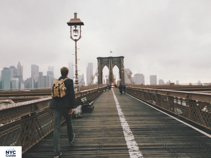
Start your walk from the Manhattan side (near City Hall Park) and walk toward Brooklyn. Once you reach DUMBO, you can explore the neighborhood, grab a coffee, and photograph the bridge from the famous perspective under the Manhattan Bridge.
Admission: Free.
Best time to visit: Sunrise or early morning on weekdays. Midday on weekends, the bridge becomes very crowded, and cyclists compete for space with pedestrians.
Safety tip: Stay in the pedestrian lane, not the bike lane. This sounds obvious, but it is one of the most common mistakes tourists make on the bridge.
How to Use an Atlas in NYC Travel
Using a travel atlas effectively is a skill that can save you hours of confusion. Here are some practical tips.
Start with the borough overview. Before drilling down into neighborhoods, understand where each borough sits geographically. This prevents you from planning a day that requires you to travel from the far end of Brooklyn to the northern Bronx — which could cost you two or three hours just in transit.
Group attractions by proximity. A good NYC atlas guide shows you which landmarks are close together. For example, MoMA, Rockefeller Center, and Bryant Park are all within walking distance in Midtown. The 9/11 Memorial, Charging Bull, and the Staten Island Ferry terminal are all in Lower Manhattan. Grouping them saves money and time.
Learn the subway map alongside the street map. The NYC subway is your most efficient tool for moving between boroughs and across long distances. Combine your physical or digital map with the subway map to understand how transit connects your sightseeing stops.
Mark your accommodation first. Once you know where you are staying, plan outward from there. If you are in Midtown, start with Midtown and Uptown attractions, then do day trips to Brooklyn or Queens.
Use walking distances wisely. Manhattan is very walkable, especially between 14th Street and 72nd Street. We walked from the 9/11 Memorial to Times Square in under an hour and discovered neighborhoods we never would have seen from a subway window.
Digital vs Physical Atlas
Both formats have real advantages depending on how you travel.
Digital Atlas (Apps and Online Maps)
A digital NYC atlas through Google Maps, Apple Maps, or dedicated travel apps offers real-time transit updates, turn-by-turn navigation, live reviews, and offline download options. You can search for specific places, check hours, and reroute instantly if something changes.
The downside is battery dependency. If your phone dies, you are stranded. Always carry a portable charger in New York City.
Recommended apps: Google Maps (best transit directions), Citymapper (excellent for subway routes), and NYC Ferry app (for waterway routes).
Physical Atlas or Map
A printed map or physical travel atlas does not need Wi-Fi or battery power. It gives you a broad overview that is sometimes easier to understand than zooming in and out on a small screen. Many hotels and visitor centers still hand out free NYC maps.
The disadvantage is that printed maps do not update in real time. If a subway line is running with delays or a landmark is closed for renovation, your paper map will not know.
Best approach: Download offline maps on your phone as a primary navigation tool. Carry a small printed map as a backup. This combination worked very well for us during a trip where we lost cell service in a long underground subway section.
| Feature | Digital Atlas | Physical Atlas |
| Real-time updates | Yes | No |
| Battery required | Yes | No |
| Best for transit | Yes | Limited |
| Overview planning | Moderate | Excellent |
| Cost | Free | Free to low cost |
FAQs
For most visitors, Google Maps with offline NYC maps downloaded works best. It covers transit, walking, and driving. Pair it with a free printed map from your hotel for backup.
New York City has five boroughs: Manhattan, Brooklyn, Queens, The Bronx, and Staten Island. Each borough has its own distinct neighborhoods, culture, and attractions.
Manhattan is the easiest borough to navigate, thanks to its numbered street and avenue grid system. Most major tourist landmarks are also concentrated here, making it the logical starting point for any first visit.
The NYC subway is the most efficient way to travel between boroughs. Bridges, ferries, and buses also connect them. The Staten Island Ferry is a free option and doubles as a scenic experience.
Central Park, the Statue of Liberty, the Brooklyn Bridge, Times Square, the Empire State Building, and the 9/11 Memorial are consistently ranked among the top landmarks in the city.
Yes, New York City is generally very safe for tourists. Like any major city, it is important to stay aware of your surroundings, keep your belongings secure in crowded areas, and stick to well-lit streets at night. Tourist-heavy areas are heavily patrolled.
Final Thoughts
New York City is one of the most exciting destinations in the world but it rewards planning. A solid NYC atlas guide helps you understand the city’s layout, prioritize your time, and move between its incredible neighborhoods with confidence.
Start with the borough overview. Pick two or three areas to focus on each day. Group nearby landmarks together. Use the subway for longer distances and walk whenever possible to truly experience the city at street level.
Whether you are standing on the Brooklyn Bridge at sunrise, wandering through Central Park, or catching a ferry toward the Statue of Liberty, New York City delivers moments that stay with you long after you leave. Use this guide as your starting point then let the city surprise you.